Palo Duro Canyon Is the Second-Largest Canyon in America. Most Road Trippers Drive Past the Texas Panhandle Without Stopping
We may earn money or products from the companies mentioned in this post. This means if you click on the link and purchase the item, I will receive a small commission at no extra cost to you ... you're just helping re-supply our family's travel fund.
The Texas Panhandle sits directly along the I-40 corridor connecting Oklahoma City to Albuquerque, which means millions of cross-country drivers pass through it every year, and the vast majority of them treat it as a stretch of flat highway to get through rather than a destination in its own right. That is a mistake. Palo Duro Canyon, just south of Amarillo near the small college town of Canyon, is the second-largest canyon system in the United States, and the region around it holds enough genuine history and roadside oddity to justify a full day off the interstate.
A Canyon Most of the Country Has Never Heard Of
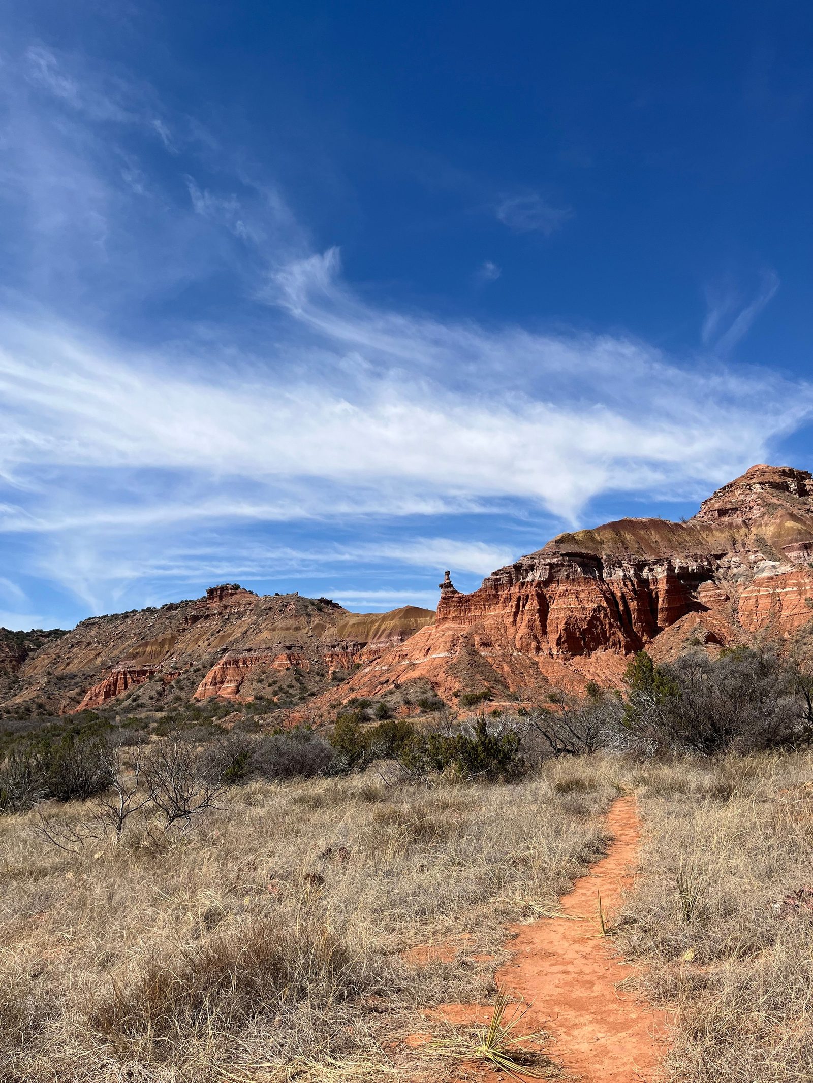
Palo Duro Canyon stretches roughly 120 miles long and reaches depths of up to 800 feet, carved by the Prairie Dog Town Fork of the Red River into layers of red, orange, and maroon rock that most visitors assume they would have to fly to Arizona to see, according to Texas Parks and Wildlife’s official park page. The state park portion is developed with hiking and mountain biking trails, camping, and the Lighthouse Peak formation that has become the canyon’s signature image, while the outdoor musical TEXAS Outdoor Musical runs seasonal performances in an amphitheater built directly into the canyon wall, a genuinely unusual venue that combines Panhandle history with a live production staged against actual 250-million-year-old rock.
The canyon’s human history runs deep. It was the site of the final major battle of the Red River War in 1874, when the US Army forced the last free-roaming Southern Plains tribes, including Comanche and Kiowa bands, onto reservations, a history explored in exhibits at the nearby Panhandle-Plains Historical Museum in Canyon, one of the largest history museums in Texas, according to a travel guide to Canyon, Texas.
Amarillo’s Route 66 Roadside Weirdness
Amarillo, the Panhandle’s largest city and the region’s transportation hub, sits directly on the historic Route 66 alignment and has leaned into that identity with Cadillac Ranch, ten vintage Cadillacs buried nose-down in a field just outside town, covered in decades of visitor graffiti and spray paint, one of the most photographed roadside art installations in the country. The Road Trip USA guide to the region pairs Cadillac Ranch with Palo Duro Canyon as the two anchor stops for anyone doing the classic Route 66 drive through the Panhandle, arguing the combination of ironic roadside art and genuine natural wonder captures something distinctly Texan about how the state treats both spectacle and scenery.
- Palo Duro Canyon runs roughly 120 miles long and up to 800 feet deep, the second-largest canyon system in the US
- The canyon was the site of the final major battle of the 1874 Red River War
- The TEXAS Outdoor Musical performs in an amphitheater built into the canyon wall
- Cadillac Ranch near Amarillo features ten vintage Cadillacs buried nose-down, open for visitors to spray paint
Why the Panhandle Gets Skipped Anyway
The Panhandle’s biggest obstacle to tourism is not a lack of things to see but a genuine geographic isolation problem. Amarillo sits roughly 350 miles from Dallas, 280 miles from Oklahoma City, and more than 500 miles from Denver, distant enough from any major metro that it rarely functions as a weekend trip and instead depends almost entirely on people already driving through on I-40 deciding to get off the highway. That dependence on drive-through traffic rather than deliberate destination travel means the region’s tourism economy rises and falls with interstate traffic patterns and gas prices more than with any marketing campaign the local tourism boards run.
The State Park’s Own Complicated History
Palo Duro Canyon State Park was established in 1934 and built out in part through the Civilian Conservation Corps, whose stonework can still be seen in several of the park’s trail structures and the visitor facilities that remain in use today, a detail that connects a visit to the canyon to a specific, tangible piece of Depression-era federal history most visitors have no reason to know about until they are standing in front of a CCC-built structure. The park’s development in the 1930s came six decades after the Red River War fighting that had taken place on the same ground, meaning the canyon has functioned as a site of forced removal, then ranching, then federally funded recreation development, all within roughly sixty years, a compressed timeline of very different uses for the same striking landscape.
For a traveler mapping out an actual stop, the practical version looks like this: enter the park early to beat the Texas Panhandle heat, hike the Lighthouse Trail, a roughly six-mile round trip to the canyon’s signature rock formation, spend the afternoon in Canyon at the Panhandle-Plains Historical Museum, and finish in Amarillo with Cadillac Ranch before dinner. It is a full day, entirely achievable as a detour off I-40, and it delivers more actual geological and historical substance than the flat, featureless reputation the Panhandle has among people who have only ever seen it from the interstate.
The region’s isolation has also preserved a specific slice of Texas culture that has mostly disappeared from more heavily trafficked parts of the state, ranching families whose land has stayed in the same hands for generations, small-town Main Streets in Canyon and nearby communities that never got hollowed out by big-box retail the way many similarly sized towns did, and a slower pace that visitors from Dallas or Austin often describe as feeling like stepping back several decades. Whether that qualifies as charm or simple economic stagnation depends on perspective, but it is precisely the kind of unpolished, unmarketed Americana that has become genuinely rare along the interstate highway system.
For the traveler willing to actually stop, the payoff is a canyon most Americans could not place on a map, a Wild West battle history most textbooks skip, and a piece of Route 66 kitsch that has become genuinely iconic despite requiring a detour most people never make. A single day trip out of Amarillo, hitting Palo Duro in the morning and Cadillac Ranch on the way back through town, covers more actual American history and geology than most people manage on an entire week-long national park vacation, and it sits directly along one of the country’s busiest cross-country driving routes the whole time.