Dead Horse Point Sits 2,000 Feet Above the Colorado River. Here’s the Grim Legend Behind Its Name
We may earn money or products from the companies mentioned in this post. This means if you click on the link and purchase the item, I will receive a small commission at no extra cost to you ... you're just helping re-supply our family's travel fund.
Dead Horse Point State Park in southeastern Utah sits on a narrow peninsula of rock about 2,000 feet above a sweeping gooseneck bend in the Colorado River. Its name comes from a grim legend: cowboys once used the point as a natural corral for wild mustangs, and a group of horses left behind died of thirst there, within sight of the river far below.
Utah State Parks tells the story this way. Around the turn of the 20th century, cowboys rounded up wild mustangs roaming the mesa top and herded them across a narrow neck of land onto the point. The neck, only about 30 yards wide, was fenced off with branches and brush, creating a corral with sheer cliffs on every other side. Cowboys picked the horses they wanted and let the rest go. But one time, for reasons no one knows, horses were left corralled on the waterless point and died, with the Colorado River 2,000 feet below.
There are other stories about how the point got its name, and the legend cannot be confirmed. But it has stuck, and the view that comes with it is one of the most dramatic in the Southwest. Here is the story in more detail and how to visit.
The legend behind the name Dead Horse Point
Dead Horse Point is a peninsula connected to the larger mesa by that narrow neck. The geography explains why the legend makes sense. A small crew could block the neck and hold an entire herd on the point, since the surrounding cliffs drop away hundreds of feet. No fences were needed except at that one narrow passage.
In the legend, the cowboys selected the horses they wanted to keep or sell, and released the culls, sometimes called broomtails. The tragedy came when a group of horses was left on the point, perhaps forgotten or perhaps trapped when the brush fence was not removed. Unable to reach water, they died of thirst with the river visible far below.
Utah State Parks acknowledges that there are many stories about how the point got its name. The mustang legend is the most widely repeated, and it is the one the park itself shares with visitors.
What you see from the point
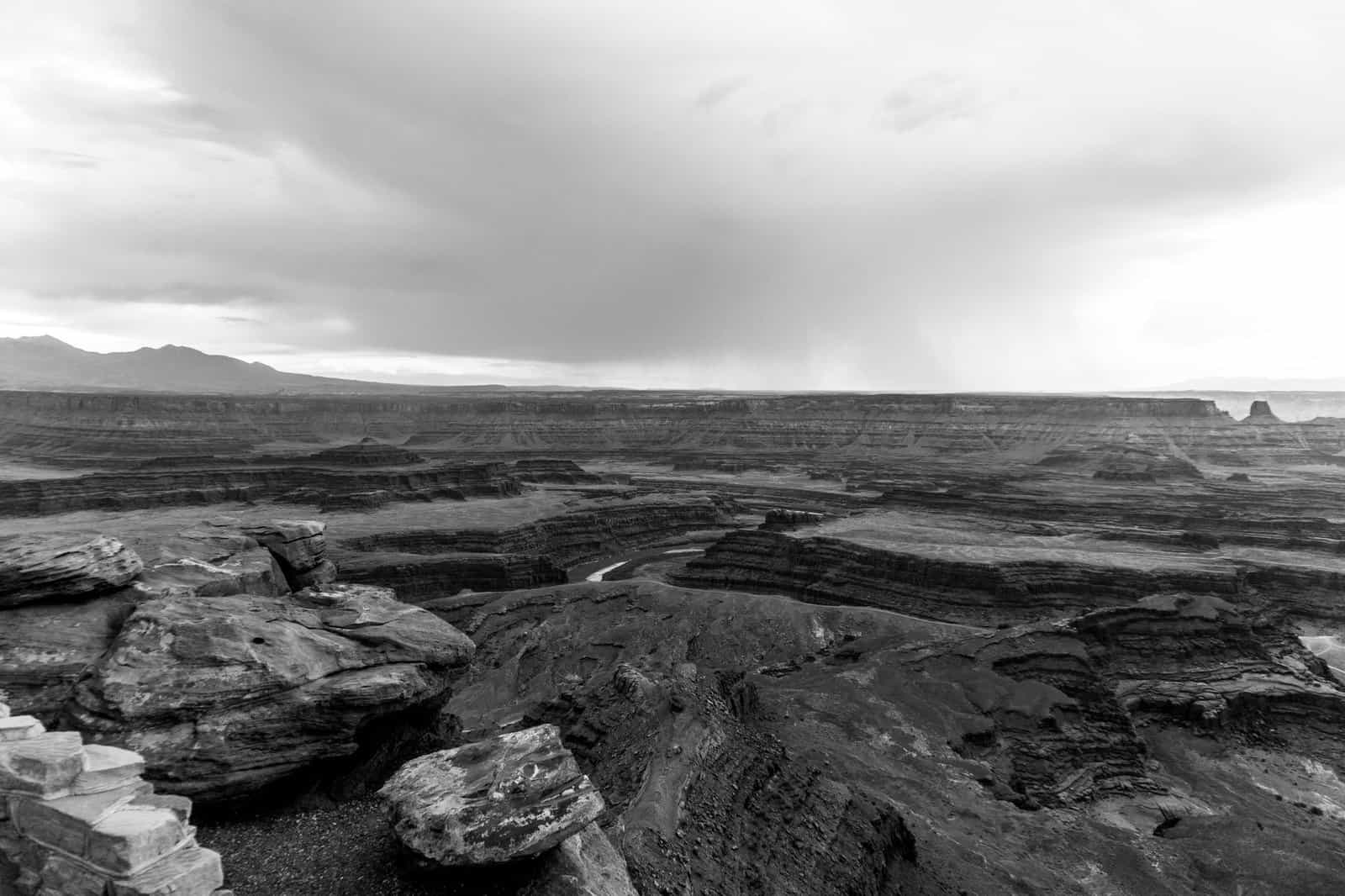
From the main overlook at the tip of the peninsula, you look down roughly 2,000 feet to a gooseneck, a tight horseshoe-shaped bend in the Colorado River. Layers of red, orange, and white sandstone step down toward the water. In the distance, you can see parts of Canyonlands National Park, the La Sal Mountains, and wide expanses of canyon country.
One unexpected sight is a set of bright blue ponds in the distance. These are evaporation ponds used in potash mining. The vivid color comes from dye added to speed evaporation. They look surprising against the red rock, and they are a reminder that this landscape is also a working one.
Visiting Dead Horse Point State Park
The park opened to the public in 1959 and covers more than 5,300 acres of high desert at about 5,900 feet. It sits between Arches and Canyonlands national parks, about 32 miles from Moab by road. Many visitors pair it with Canyonlands’ Island in the Sky district, which is reached via the same highway.
Overlooks and trails
The park has several overlooks and a network of trails:
- Dead Horse Point Overlook: The main viewpoint at the tip of the peninsula, with a short paved path and railings.
- East Rim Trail: A trail along the eastern edge of the mesa with views toward the potash ponds and the La Sal Mountains.
- West Rim Trail: A trail along the western edge with views of the Colorado River gooseneck and canyon country.
- Rim trail loop: Combining the East and West Rim trails, along with spur trails to overlooks like Basin Overlook and Bighorn Overlook, creates a longer loop. Some hikers do the full loop of about 8 miles.
- Intrepid Trail System: A network of mountain biking trails ranging from beginner to more challenging.
The rim trails have little shade, so bring water and sun protection, especially in warm months.
Dark skies
Dead Horse Point is a certified International Dark Sky Park. Its remote location and high elevation make it a popular stargazing spot. On clear nights, the Milky Way can stretch across the sky above the canyons. The park sometimes offers stargazing programs; check its event schedule.
Camping and yurts
The park has two campgrounds, Kayenta and Wingate, with sites that can be reserved. It also offers yurts, which provide a more comfortable option with beds and heating. Campgrounds and yurts often book up months in advance, especially in spring and fall.
On screen
The landscapes around Dead Horse Point have appeared in films. The final scene of Thelma and Louise, released in 1991, was filmed in this area of canyon country, and Mission: Impossible II’s opening climbing sequence was shot in the region as well. Many visitors recognize the scenery from movies, commercials, and car advertisements.
Best times to visit
Dead Horse Point is open year-round. Each season offers something different:
- Spring: Mild temperatures and wildflowers, but also busy weekends and strong winds at times.
- Summer: Hot days, cooler mornings and evenings. Sunrise and sunset are best for hiking and photography.
- Fall: Comfortable temperatures and clear skies, with busy weekends during Moab’s peak season.
- Winter: Fewer visitors and occasional snow on the canyon rims. Some trails can be icy.
Sunrise and sunset are especially beautiful. Low sun lights up the canyon walls and casts long shadows across the river bend.
Fees and practical tips
Dead Horse Point charges a day-use fee per vehicle. Check Utah State Parks for current fees and hours. National park passes do not cover state park fees.
A few practical tips:
- Bring water. There are limited water sources in the park.
- Stay behind railings and away from cliff edges. Rock can crumble, and drops are sheer.
- Keep pets on leashes and away from edges.
- Watch for weather. Thunderstorms in summer can bring lightning to exposed rims.
- Dress in layers. Temperatures change quickly with elevation and time of day.
Pairing Dead Horse Point with nearby parks
Dead Horse Point fits easily into a Moab-area trip:
- Canyonlands National Park, Island in the Sky: Just past the turnoff for Dead Horse Point, with overlooks like Grand View Point and Mesa Arch.
- Arches National Park: North of Moab, with famous arches and fins. Timed-entry reservations may be required during busy seasons.
- Moab: The main town in the area, with restaurants, lodging, gear shops, and tour companies.
A common plan is to visit Mesa Arch in Canyonlands at sunrise, explore Island in the Sky in the morning, and end the day at Dead Horse Point for sunset.
Why the legend sticks
The Dead Horse Point legend endures because it fits the landscape. Standing on the point, you can see exactly how a herd could be trapped there, with sheer drops on every side and a narrow neck that a few cowboys could block. You can also see the river, so close in sight yet impossibly far below.
Whether or not every detail is true, the story gives the place a haunting edge. It turns a beautiful overlook into a reminder of how harsh this land can be.
A sample visit
Arrive mid-afternoon, stop at the visitor center for maps and information, and walk to the main overlook. Then hike part of the West Rim Trail to see the gooseneck from different angles. Stay for sunset at the main overlook, and if you are camping or staying in a yurt, remain after dark for stargazing.
Photography tips at the point
The overlook faces west and south toward the gooseneck, so late-afternoon and sunset light often paint the canyon walls in warm reds and oranges. At sunrise, the light comes from behind you on the eastern side of the mesa, lighting the La Sal Mountains and the far canyon rims. A wide-angle lens helps capture the whole river bend, while a telephoto lens can isolate patterns in the rock layers and the river below.
Wind is common on the exposed point, so a sturdy tripod helps in low light. Keep camera gear and bags away from the edge, and never step past railings for a better angle. Some of the best views come from the rim trails, where you can frame the gooseneck with junipers or slickrock in the foreground.
Accessibility
The main overlook at the tip of the point has a short paved path, making the classic view reachable for many visitors who cannot hike far. The visitor center also has viewpoints nearby. Ask staff about current accessible routes and facilities.
The bottom line
Dead Horse Point State Park overlooks a Colorado River gooseneck about 2,000 feet below, and its name comes from a legend about wild mustangs trapped and left to die on the point. The story, shared by Utah State Parks, is one of several, but the geography makes it easy to believe. Come for the legend, stay for the view, and time your visit for sunrise, sunset, or a night under some of the darkest skies in Utah.