10 Scenic Drives in Canada Worth Planning a Trip Around
We may earn money or products from the companies mentioned in this post. This means if you click on the link and purchase the item, I will receive a small commission at no extra cost to you ... you're just helping re-supply our family's travel fund.
Roads in Canada read like field notes on geology, weather, and culture. Fjord-sliced peninsulas, prairie rims, and coastlines shaped by tides pull drivers into long, unhurried stories. Distances stretch, but so does variety: Celtic fiddles on Atlantic headlands, cedar-scented rain on Pacific inlets, and northern light arcing over tundra. Seasons matter. Autumn sets hills on fire; winter carves blue shadows. What stays constant is hospitality, from diners to small museums, quietly tying big landscapes to daily life. Spring brings roadside blooms and a sense that every mile still teaches.
Icefields Parkway, Alberta
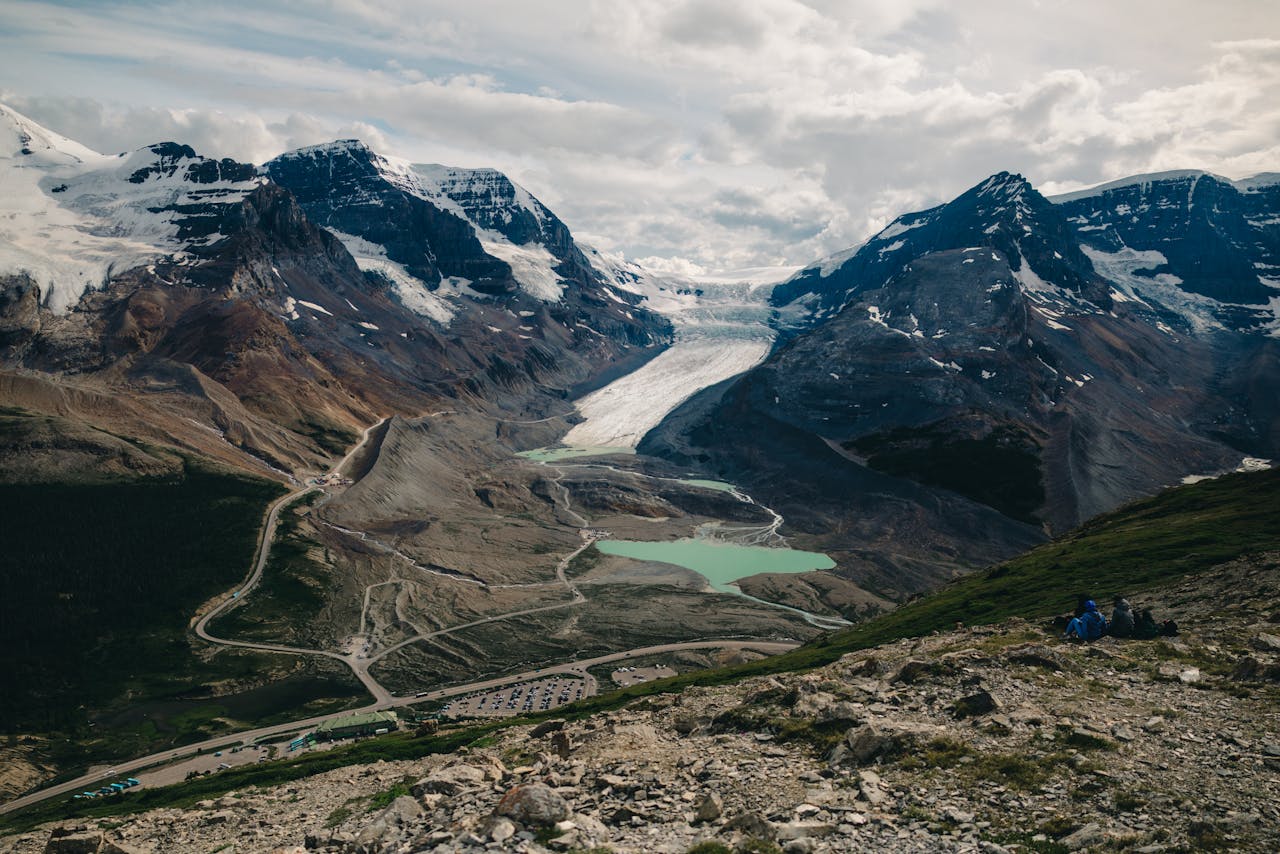
, luminous beauty. Between Lake Louise and Jasper, cliffs rise as if freshly quarried, and turquoise lakes collect the sky. Pullouts frame Crowfoot, Peyto, and the Athabasca Glacier, while bighorn sheep edge the shoulders like sentries. In fall, larch needles turn alpine basins gold; in spring, meltwater fattens creeks that thread the valley. The road moves steadily, inviting short walks to falls and moraines where silence expands scale and time.
Cabot Trail, Nova Scotia
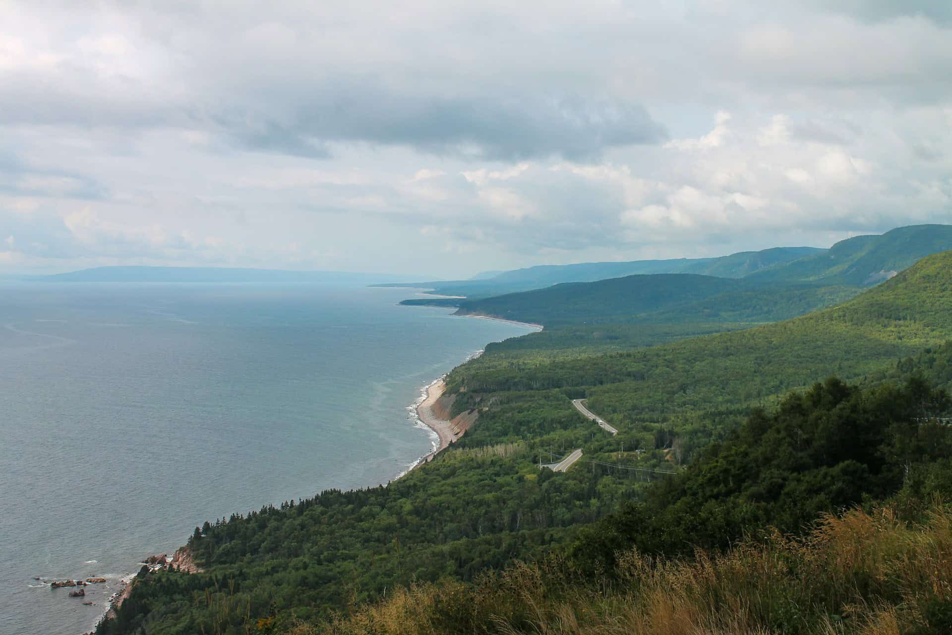
The Cabot Trail curls around Cape Breton Highlands where cliffs meet a restless Atlantic. Acadian, Gaelic, and Mi’kmaq traditions color daily life, from kitchen parties and fiddle tunes to woven tartans and drum circles. Switchbacks climb to wind-scoured headlands, then drop into coves thick with spruce and salt. Fog in June softens edges; October sets hardwoods blazing. Small towns turn into lantern-lit halls after dark, keeping stories, songs, and seafood at the center of the evening.
Sea-to-Sky Highway, British Columbia
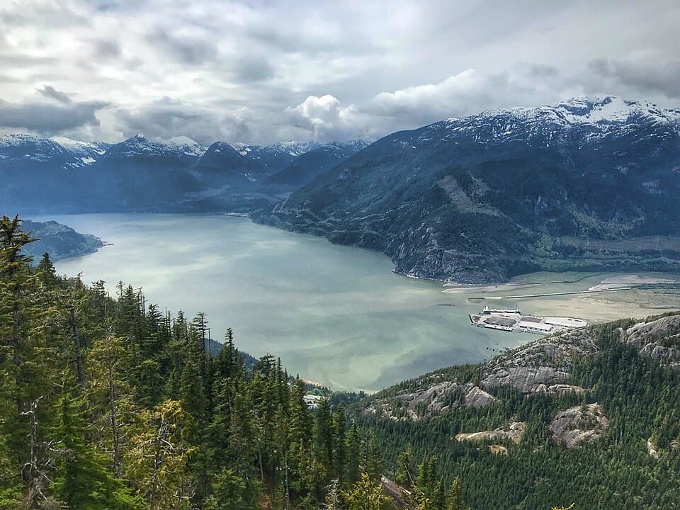
Highway 99 moves from tidewater to granitic skyline in a few steep hours. Howe Sound flickers beside ferry lanes, then Squamish opens with climbers on the Stawamus Chief and eagles spiraling over estuaries. Waterfalls braid the forest, and glacial valleys hold cedar and hemlock that smell of rain even in sun. Whistler brings alpine meadows and quiet lakes, while ski runs sleep through wildflower season. Every curve keeps the ocean close, even when the highway climbs into cool, high light.
Viking Trail, Newfoundland and Labrador
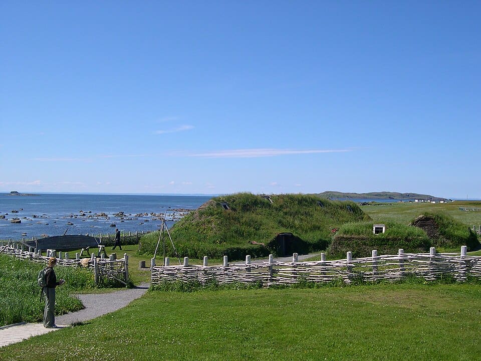
The Viking Trail follows a coast where geology and story meet. Gros Morne’s fjords and tablelands feel ancient and otherworldly, while outports stitch bright houses against green headlands. At the peninsula’s tip, L’Anse aux Meadows confirms Norse arrival with turf outlines and artifact rooms, a rare page of transatlantic history. Summer sets whales rolling offshore and, some years, icebergs drifting like blue cathedrals. Kitchens answer the wind with chowder, bakeapples, and long, easy conversations.
Lake Superior North Shore, Ontario
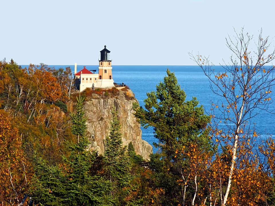
freighters ride far offshore. Jack pine and granite define the Canadian Shield, then give way to beaches of tumbled stone and glassy, cold coves. Agawa Rock pictographs hold canoe-red stories at the lake’s edge, while Ouimet Canyon and Sleeping Giant reset scale with abrupt depth and height. Thunderheads form quickly; so do clearings. Between Sault Ste. Marie and Thunder Bay, each overlook invites unplanned stops and steady, contented quiet.
Gaspésie Loop, Québec
Route 132 threads villages that live by tides, weather, and the seasons of fish. Forillon’s cliffs carry seabirds on stalled wind, and Percé Rock stands like a gate at the Gulf. Rivers spill out of the Chic-Chocs thick with spruce and maple before widening into marsh and eelgrass. Smokehouses work quietly behind painted houses as crab pots and drying racks mark the yards. In July and Aug., daylight lingers for headland walks, lighthouse visits, and long, simple suppers.
Fundy Coastal Drive, New Brunswick

Fundy writes its signature twice a day in vertical feet. The route moves from Hopewell’s sculpted rocks to red-sand coves, sea caves, and the switchbacks of the Fundy Trail Parkway. Fishing wharves tilt with the tide, and fog bells carry across the bays. Low tide reveals seaweed gardens and ribbed flats; high tide remakes them into deep channels. Weather turns fast, but café windows and lighthouses stay warm, steady, and bright along this bold water.
Dempster And Inuvik–Tuktoyaktuk Highways, Yukon & Northwest Territories
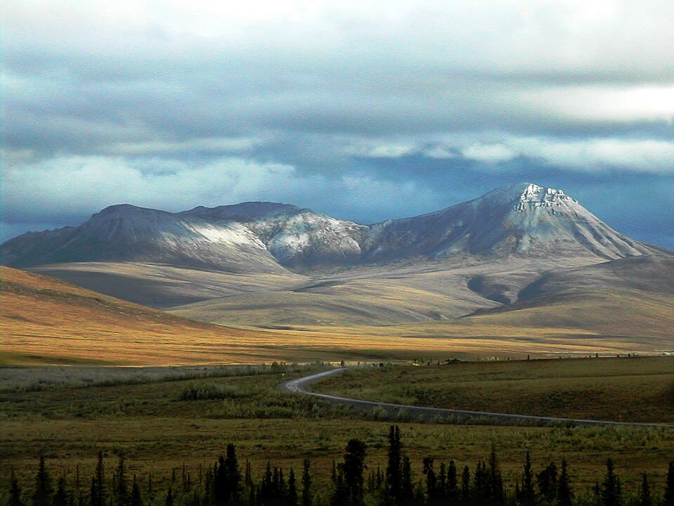
Gravel and sky dominate the run toward the Arctic Ocean. The Dempster crosses tundra, shale peaks, and river ferries until the Mackenzie Delta breaks into a braid of water and willows. From Inuvik, the all-season road noses north on frost-heaved ground to Tuktoyaktuk, where pingos rise like quiet pyramids beside the sea. Summer brings wildflowers and long light; fall kindles the hills in russet and gold. The return drive feels different, as if the horizon learned a new language.
Pacific Rim Highway, British Columbia
Highway 4 threads cathedral forest before easing into beaches broad enough to clear the mind. Sitka spruce lean over blackwater streams, and nurse logs turn to gardens under patient rain. Tofino and Ucluelet move at surf tempo, with working harbors, small galleries, and tidelines where storms write calligraphy in kelp. Winter invites storm watching; summer plays softer with sandbars and morning fog. The coast keeps its mystery but offers generous shelter in bakeries, lodges, and quiet camp kitchens.
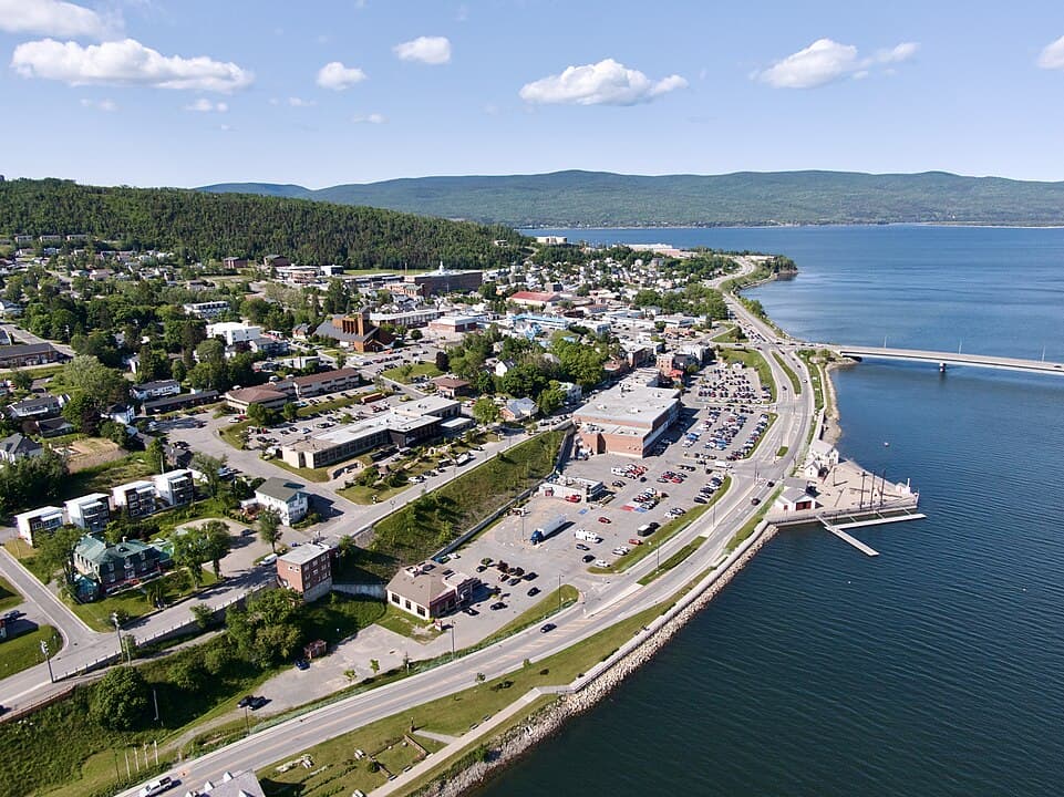
St. Lawrence Route, Charlevoix, Québec
Route 362 hangs above the river with barn-red farms on one side and a steel-blue estuary on the other. Hills fold toward coves where belugas sometimes surface like pale commas, and roadside stands trade in cider, cheese, and berries. The distance is short, but variety is constant: tidal flats, cliff-top chapels, and the far line of ships bound for the ocean. Autumn tastes of apple and spruce; spring returns thaw, lambs in fields, and soft, salt-tinged air.