We may earn money or products from the companies mentioned in this post. This means if you click on the link and purchase the item, I will receive a small commission at no extra cost to you ... you're just helping re-supply our family's travel fund.
America’s biggest landmarks pull millions each year, yet some of its most rewarding places remain surprisingly quiet. Beyond the headline national parks and crowded city icons, there are remote shorelines, dramatic desert basins, ancient forests, and geological oddities that offer richer, calmer experiences. This list highlights 24 overlooked destinations that deliver genuine wonder without overwhelming crowds. Each one combines scenery, history, and measurable facts to help you plan wisely while discovering places many travelers still miss.
1. Great Basin National Park
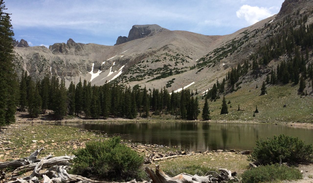
Tucked against the Utah border, this park spans over 77,000 acres yet sees barely 140,000 visitors annually. Wheeler Peak rises to 13,063 feet, often holding snow well into June. Ancient bristlecone pines here exceed 4,000 years in age, making them among Earth’s oldest living trees.
Lehman Caves stretches for nearly 2 miles underground, filled with rare shield formations. Night skies are exceptionally dark, with elevation above 6,800 feet improving visibility. Summer highs average 80°F, while winter transforms the peaks into a quiet alpine escape.
2. Dry Tortugas National Park
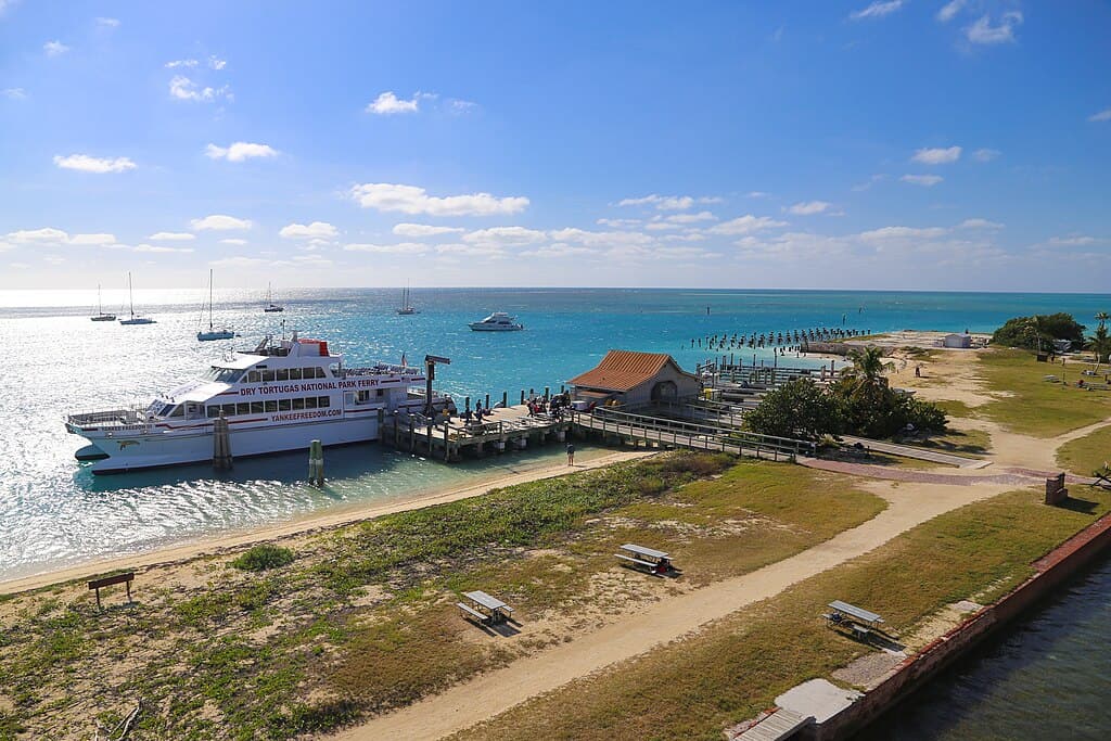
Located 70 miles west of Key West, this 100-square-mile park is 99% water. Fewer than 80,000 visitors make the ferry or seaplane journey each year. The massive Fort Jefferson, begun in 1846, contains over 16 million bricks.
Coral reefs surrounding the islands support vibrant marine life in waters often exceeding 80°F during summer. Snorkeling visibility regularly reaches 30 feet. With no hotels on site and limited daily access, sunsets feel private, framed by turquoise shallows and seabirds circling historic brick walls.
3. Craters of the Moon National Monument
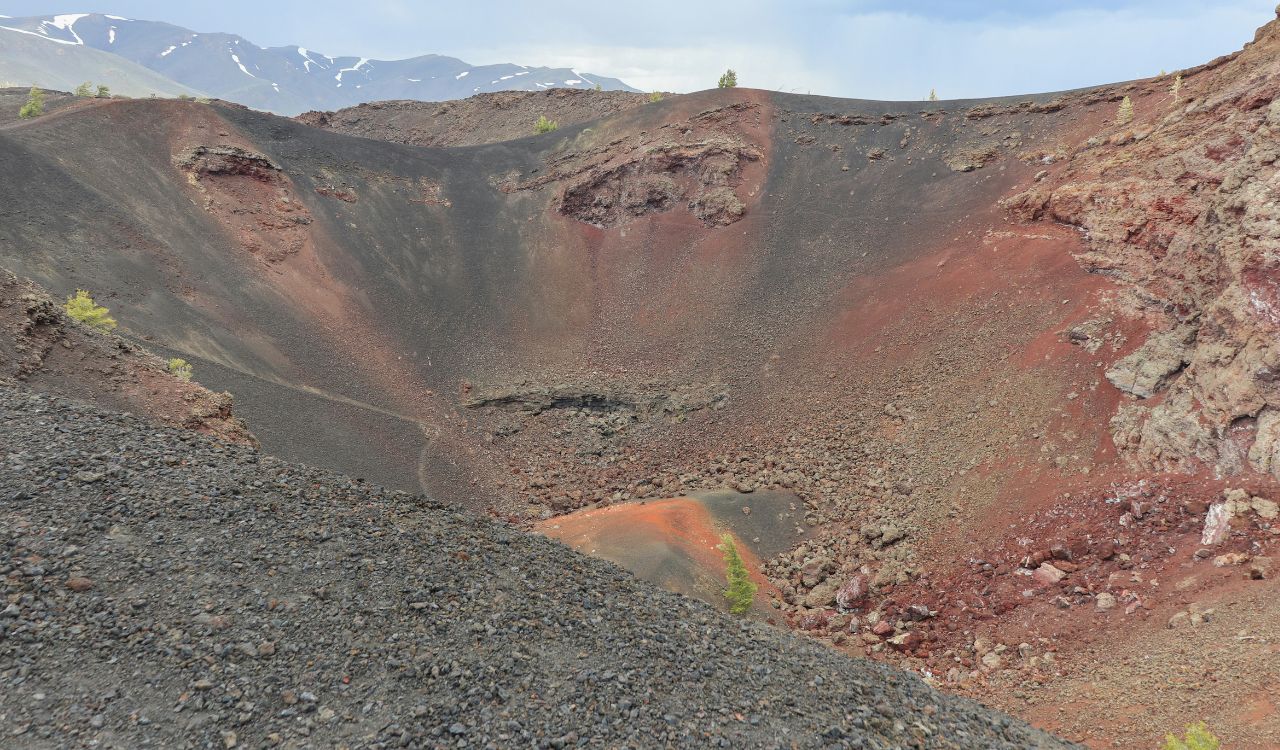
This volcanic preserve covers 750,000 acres of hardened lava, cinder cones, and sagebrush flats. Some eruptions here occurred as recently as 2,000 years ago. The landscape resembles a frozen ocean of basalt stretching for nearly 53 miles.
Visitors can walk a 7-mile scenic drive or explore lava tubes requiring free cave permits. Elevations average 5,900 feet, creating cool evenings even when summer highs reach 85°F. With annual visitation under 300,000, it feels wide open, raw, and unexpectedly cinematic.
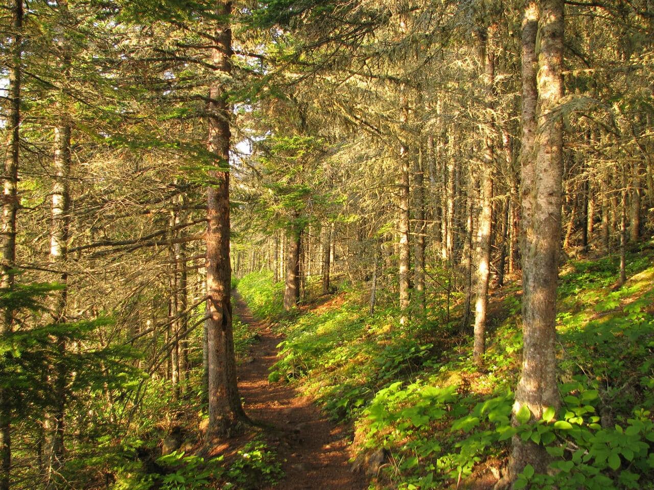
4. North Cascades National Park
Home to more than 300 glaciers, this park contains the most glacial ice in the lower 48 states. Despite dramatic peaks rising above 9,000 feet, fewer than 40,000 people visit the core park each year.
Diablo Lake’s turquoise water glows from suspended glacial silt. Over 400 miles of trails cross alpine meadows and dense cedar forests. Rainfall varies widely, with western slopes receiving over 70 inches annually. The combination of jagged summits and minimal crowds makes it feel truly wild.
5. Cumberland Island
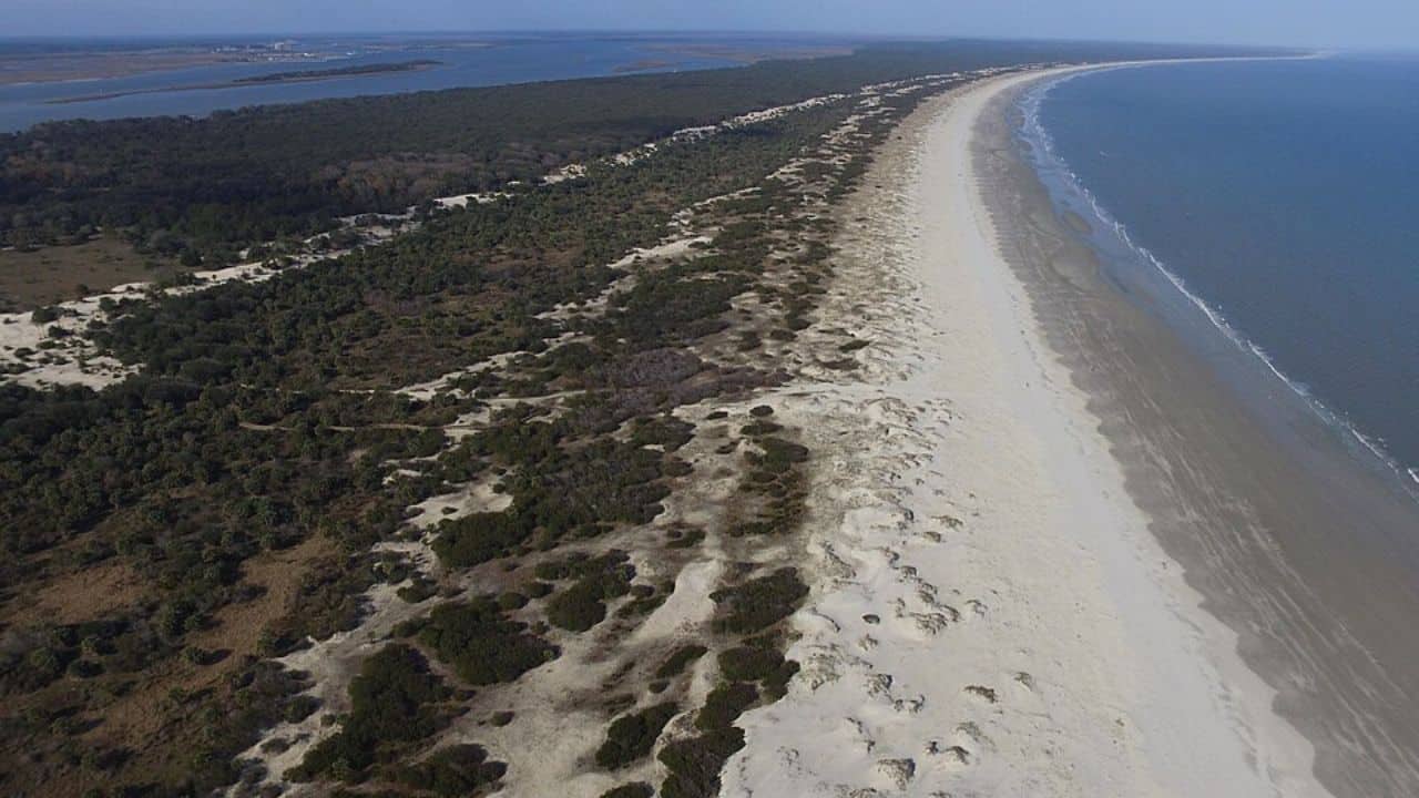
Accessible only by ferry, this barrier island stretches 17 miles along Georgia’s coast. Daily visitation is capped at 300 guests, preserving quiet beaches and maritime forests. Wild horses, descendants of colonial livestock, roam freely across dunes and grassy clearings.
The ruined Carnegie mansion, Dungeness, dates to 1884 and still stands dramatically against the sky. Summers average 88°F, while winter brings mild 60°F afternoons. With over 9,800 acres of designated wilderness, the island feels peaceful and intentionally unhurried.
6. Chiricahua National Monument
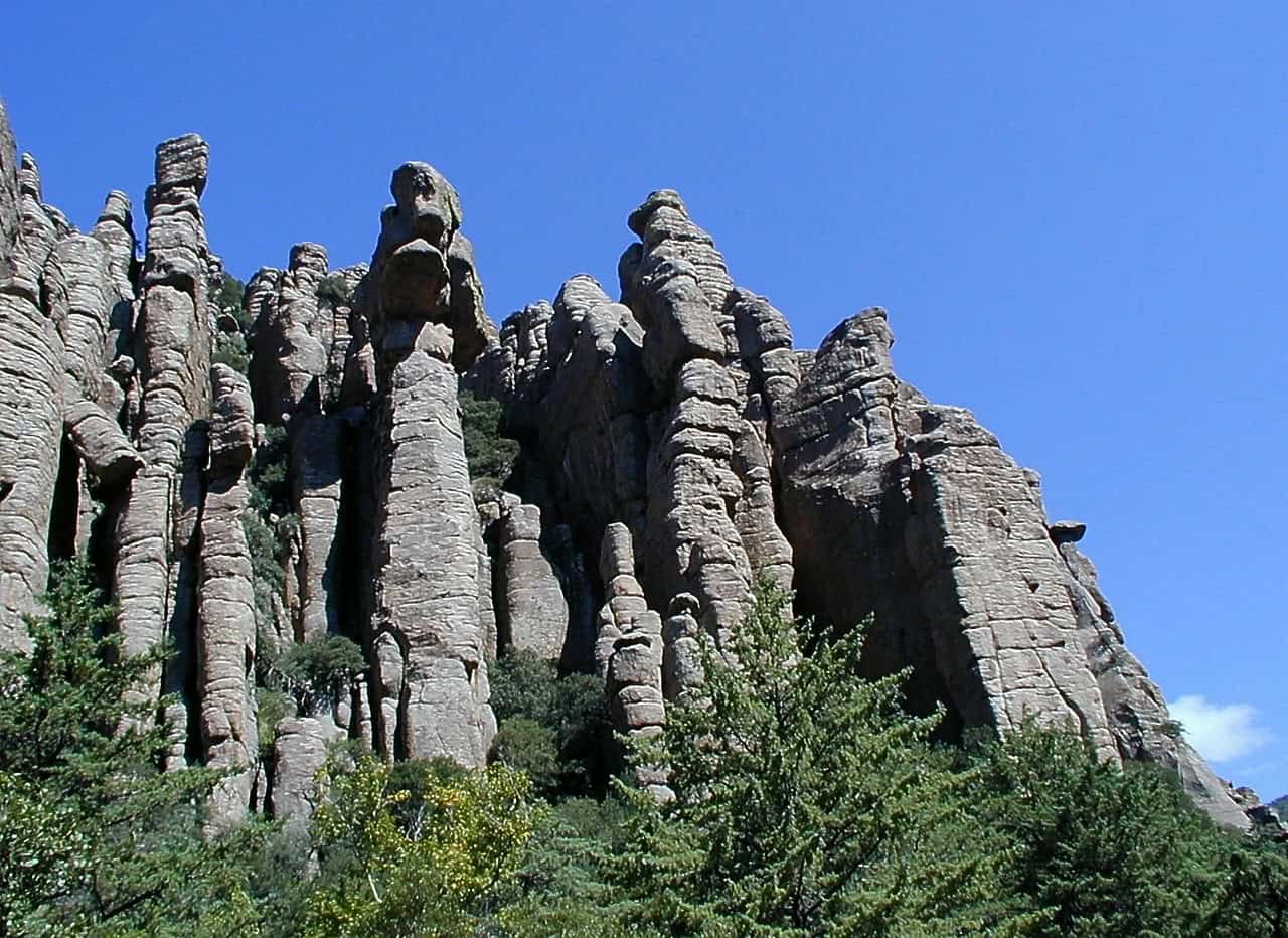
Covering nearly 12,000 acres, this “Wonderland of Rocks” formed from volcanic ash 27 million years ago. Towering rhyolite pinnacles rise over 150 feet high, lining 17 miles of hiking trails.
Elevations range from 5,200 to 7,300 feet, bringing cooler temperatures than nearby deserts. Spring wildflowers bloom after limited annual rainfall of about 23 inches. Fewer than 70,000 visitors arrive yearly, making sunset hikes among balanced rock spires feel strikingly personal and quiet.
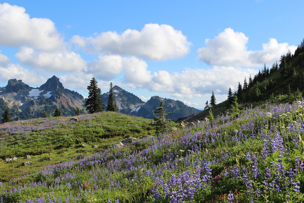
7. Tallgrass Prairie National Preserve
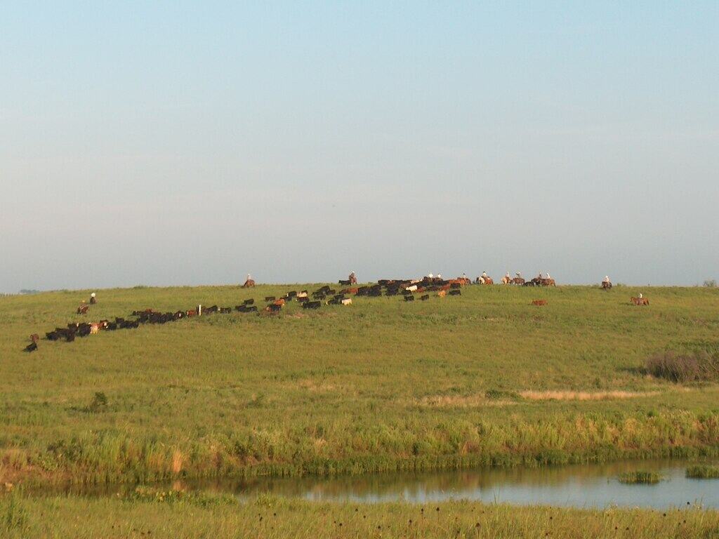
Less than 4% of original tallgrass prairie survives in North America. This 11,000-acre preserve protects rolling hills once stretching across 170 million acres. A free-roaming bison herd of roughly 100 animals grazes the grasslands.
Summer grasses can grow 8 feet tall, shifting from green to golden by autumn. Annual rainfall averages 35 inches, supporting diverse wildflowers and over 150 bird species. The open horizon and wide skies create a quiet beauty many travelers overlook.
8. Isle Royale National Park
Floating in Lake Superior, this 894-square-mile park is reachable only by boat or seaplane. Fewer than 30,000 people visit annually, mostly between June and September. Moose and wolf populations have been studied here for over 60 years.
More than 165 miles of trails cross boreal forest and rocky shoreline. Winter ice isolates the island entirely. Summer highs hover near 70°F, ideal for multi-day backpacking. The remoteness fosters a rare sense of stillness in the Midwest.
9. Guadalupe Mountains National Park
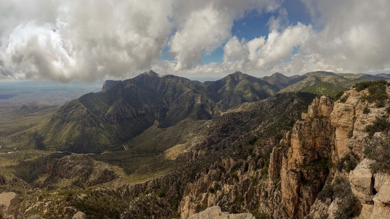
Covering 86,000 acres, this park includes Guadalupe Peak at 8,751 feet, the highest point in Texas. Annual visitation remains under 250,000 despite 80 miles of hiking trails.
McKittrick Canyon bursts into red and orange during October, unusual for West Texas. Average rainfall sits near 18 inches yearly, creating stark desert contrasts. Fossilized reef formations dating back 260 million years reveal an ancient marine past few expect in this arid landscape.
10. Apostle Islands National Lakeshore
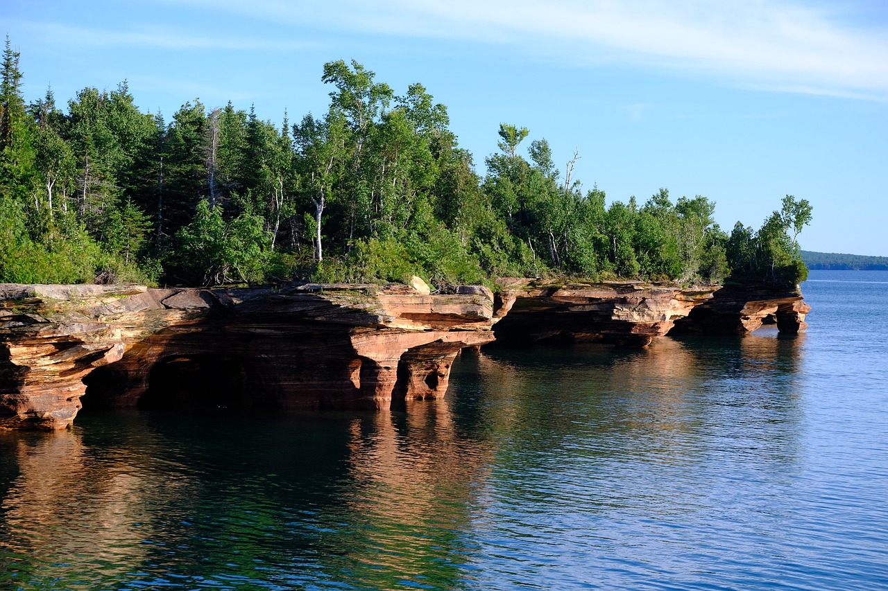
This lakeshore protects 21 islands and 12 miles of mainland cliffs along Lake Superior. Sandstone sea caves, carved over thousands of years, transform into icy formations when winter temperatures drop below 20°F.
Summer water temperatures rarely exceed 60°F, yet kayaking remains popular due to clear visibility. Lighthouses dating to the late 1800s dot several islands. With annual visitation near 240,000, it offers dramatic Great Lakes scenery without heavy national park congestion.
11. Valley of Fire State Park
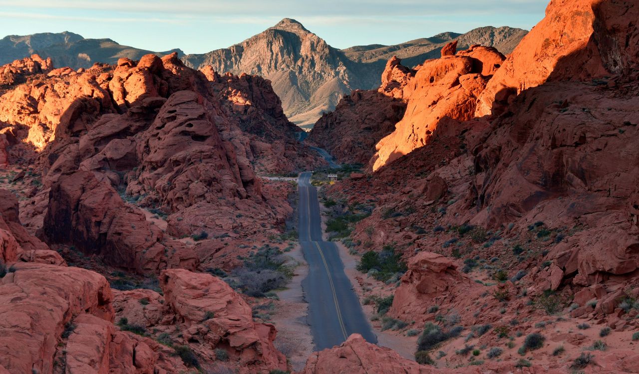
Just 50 miles northeast of Las Vegas, this 46,000-acre park erupts in layers of red Aztec sandstone formed over 150 million years ago. Despite its proximity to the Strip, annual visitation remains modest compared to major national parks.
Summer temperatures often exceed 100°F, but sunrise and winter months bring ideal hiking weather near 70°F. Petroglyphs at Atlatl Rock date back more than 2,000 years. Scenic drives stretch 10 miles, weaving between fire-colored domes and narrow slot canyons.
12. Great Sand Dunes National Park
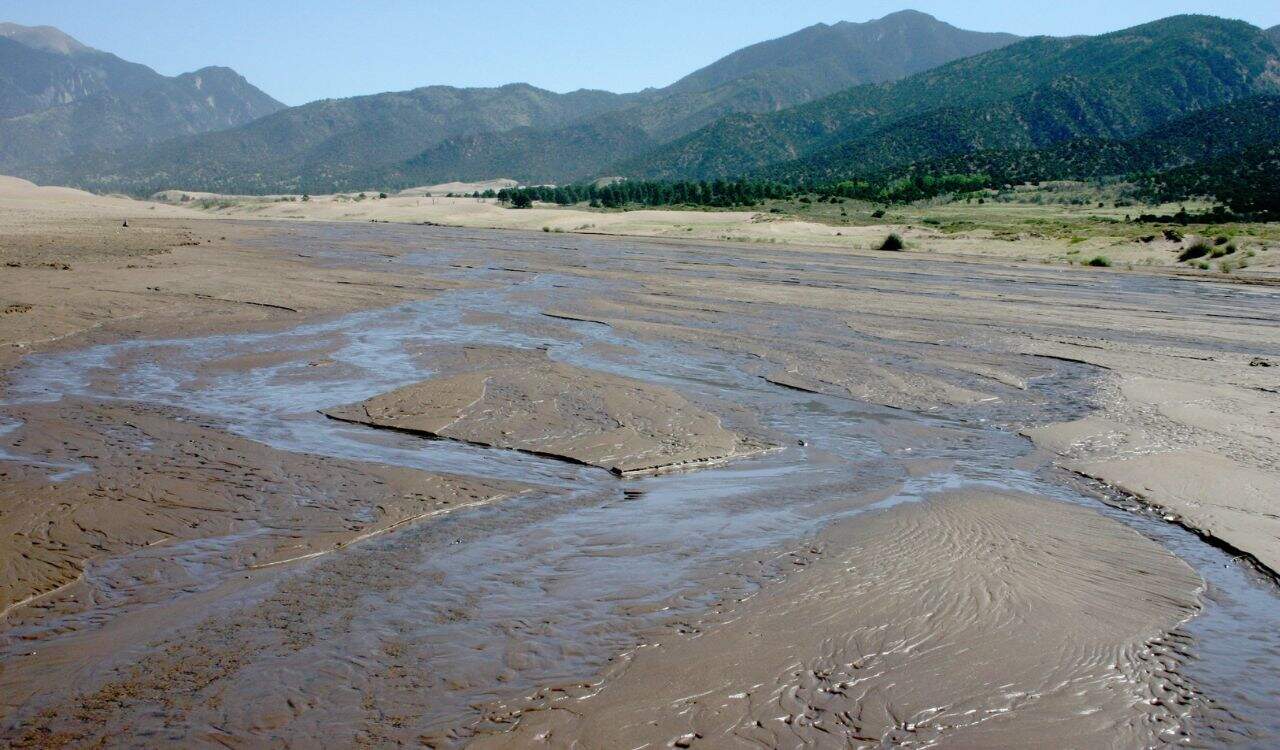
Rising dramatically against the Sangre de Cristo Mountains, these dunes reach heights of 750 feet, the tallest in North America. The park covers 149,000 acres, yet visitation averages under 500,000 annually.
Medano Creek flows seasonally each spring, creating a shallow shoreline effect at 8,200 feet elevation. Summer highs reach 82°F, though sand surfaces can exceed 140°F midday. Sandboarding and sledding are popular, while night skies reveal thousands of stars due to minimal light pollution.
13. Congaree National Park
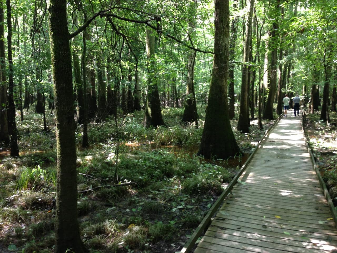
Protecting over 26,000 acres of old-growth bottomland hardwood forest, this park features some of the tallest trees in the eastern United States. Loblolly pines here surpass 160 feet in height.
The 2.4-mile elevated boardwalk loops through floodplain terrain shaped by the Congaree River. Annual rainfall averages 49 inches, sustaining rich biodiversity. Visitation typically remains under 300,000 per year, making canoe trips and late-spring synchronous firefly displays surprisingly intimate experiences.
14. The Wave
Hidden within the Coyote Buttes North area, this sandstone formation spans roughly 190 feet in length. Its swirling layers formed from Navajo sandstone about 190 million years ago.
Only 64 hiking permits are issued daily through a lottery system, maintaining fragile conditions. Summer temperatures can exceed 100°F, and the 6-mile round-trip hike crosses unmarked desert terrain. The striated orange and cream patterns appear almost painted by hand.
15. Letchworth State Park
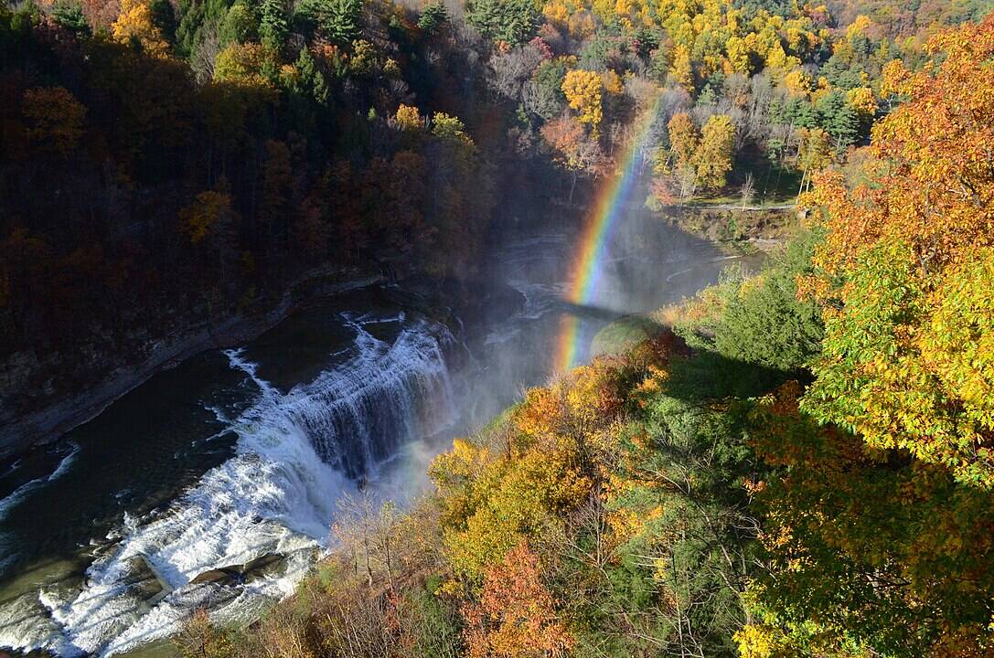
Stretching 17 miles along the Genesee River, this 14,400-acre park contains three major waterfalls. The tallest, Middle Falls, drops 107 feet into a steep gorge often compared to a smaller Grand Canyon.
Annual visitation approaches 700,000, yet crowds disperse along 66 miles of trails. Fall foliage peaks in October, when temperatures average 60°F. Hot air balloon launches frequently rise above the canyon at sunrise, offering panoramic views of layered shale cliffs.
16. Devils Kettle
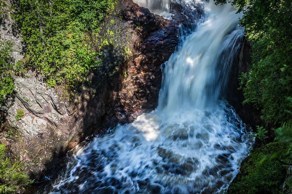
Located within Judge C.R. Magney State Park, this waterfall splits into two streams along the Brule River. One side plunges 50 feet into a visible pool, while the other disappears into a deep pothole.
For decades, scientists debated where the missing water flowed until dye testing confirmed it rejoins the river downstream. The 2-mile round-trip hike climbs roughly 175 steps. With Lake Superior nearby, summer highs average 72°F, creating a refreshing North Shore stop.
17. White Sands National Park
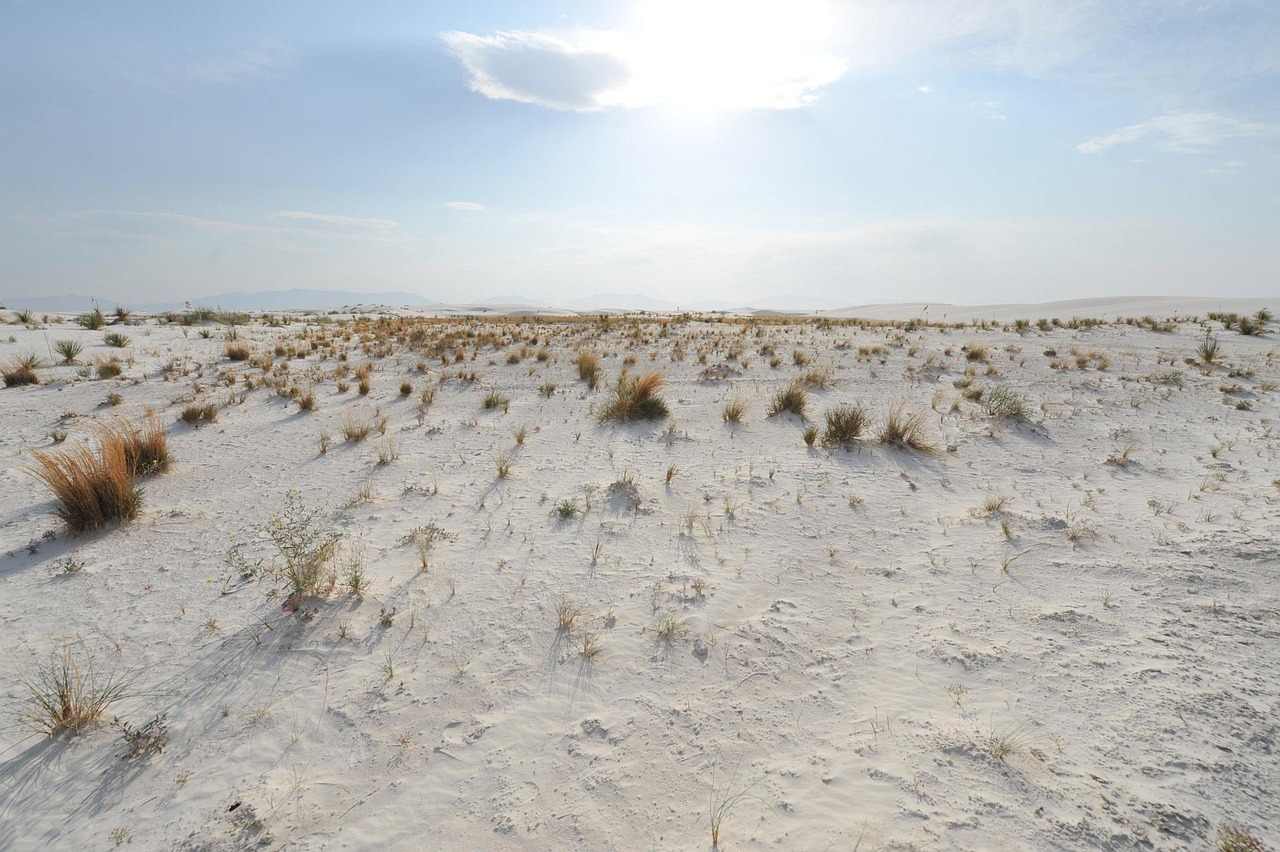
Covering 275 square miles, this park preserves the world’s largest gypsum dune field. Unlike quartz sand, gypsum remains cool underfoot even when air temperatures exceed 95°F.
Dunes can rise 60 feet high, constantly reshaped by wind. Annual visitation hovers near 600,000, far lower than nearby desert icons. Sunset paints the white landscape in soft pink and lavender tones. A 16-mile scenic drive loops through shifting terrain ideal for sledding.
18. Hocking Hills State Park
Spanning roughly 2,500 acres, this park surprises visitors with sandstone cliffs, waterfalls, and recess caves. Old Man’s Cave features a 50-foot gorge carved by centuries of erosion.
Over 25 miles of trails connect Ash Cave and Cedar Falls, the latter dropping 50 feet after heavy rain. Annual visitation approaches 4 million, yet peak crowds cluster near parking areas. Spring and fall temperatures average 65°F, ideal for quieter weekday hikes.
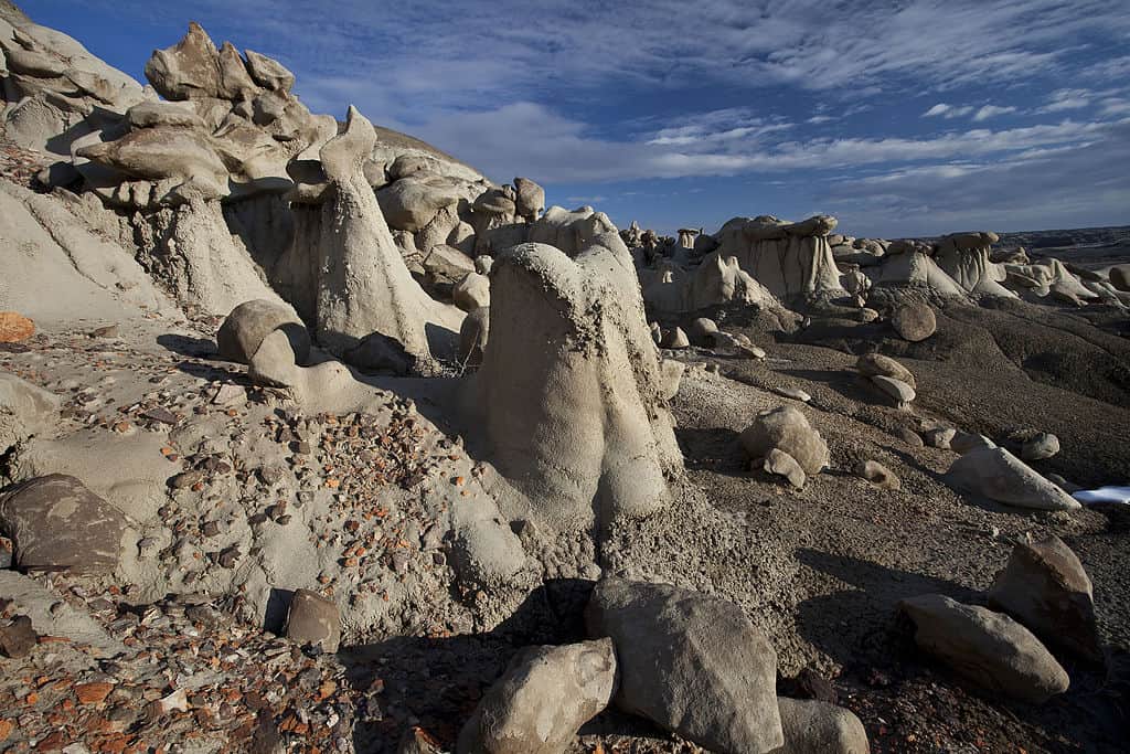
19. Bisti/De-Na-Zin Wilderness
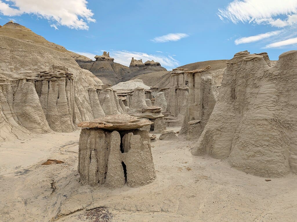
Encompassing over 45,000 acres, this wilderness feels almost extraterrestrial. Hoodoos, petrified wood, and fossil beds date back nearly 70 million years to the Late Cretaceous period.
There are no marked trails across the badlands terrain, requiring navigation skills and GPS preparation. Annual visitation remains low due to remote access roads. Daytime summer temperatures often exceed 95°F, while sunset light intensifies the gray and rust-colored formations dramatically.
20. Caddo Lake
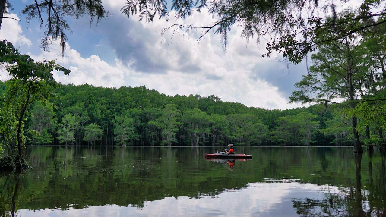
Spanning about 25,400 acres, this maze of bayous and cypress swamps forms one of the largest naturally formed lakes in the South. Bald cypress trees draped in Spanish moss rise directly from the water.
The lake supports over 70 fish species and more than 200 bird species annually. Average summer highs reach 92°F, making early-morning paddling ideal. With limited large-scale development, kayaking through narrow channels feels cinematic and surprisingly tranquil.
21. Mount Desert Island
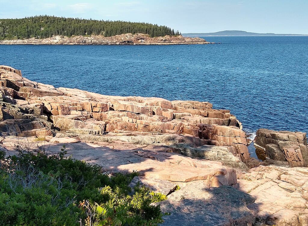
Covering 108 square miles along Maine’s rocky coast, this island is best known as the home of Acadia, yet quieter corners remain overlooked. Bar Harbor draws summer visitors, but less-traveled roads circle granite headlands and fishing harbors.
Cadillac Mountain rises 1,530 feet, offering one of the earliest sunrise views in the U.S. Summer highs average 75°F, while fall brings crisp 60°F days and colorful foliage. Lobster boats, carriage roads spanning 45 miles, and coastal hikes create a balanced blend of nature and maritime culture.
22. Black Canyon of the Gunnison National Park
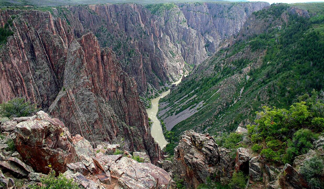
This 30,750-acre park protects one of the steepest canyons in North America. Sheer walls plunge nearly 2,000 feet to the Gunnison River, with some cliffs dropping almost vertically for 1,500 feet.
Annual visitation remains under 350,000, far lower than Colorado’s more famous parks. The scenic South Rim Drive extends 7 miles with 12 overlooks. Summer highs reach 80°F, yet shaded inner canyon routes stay cooler. The narrow canyon allows only minutes of direct sunlight at certain points.
23. Pictured Rocks National Lakeshore
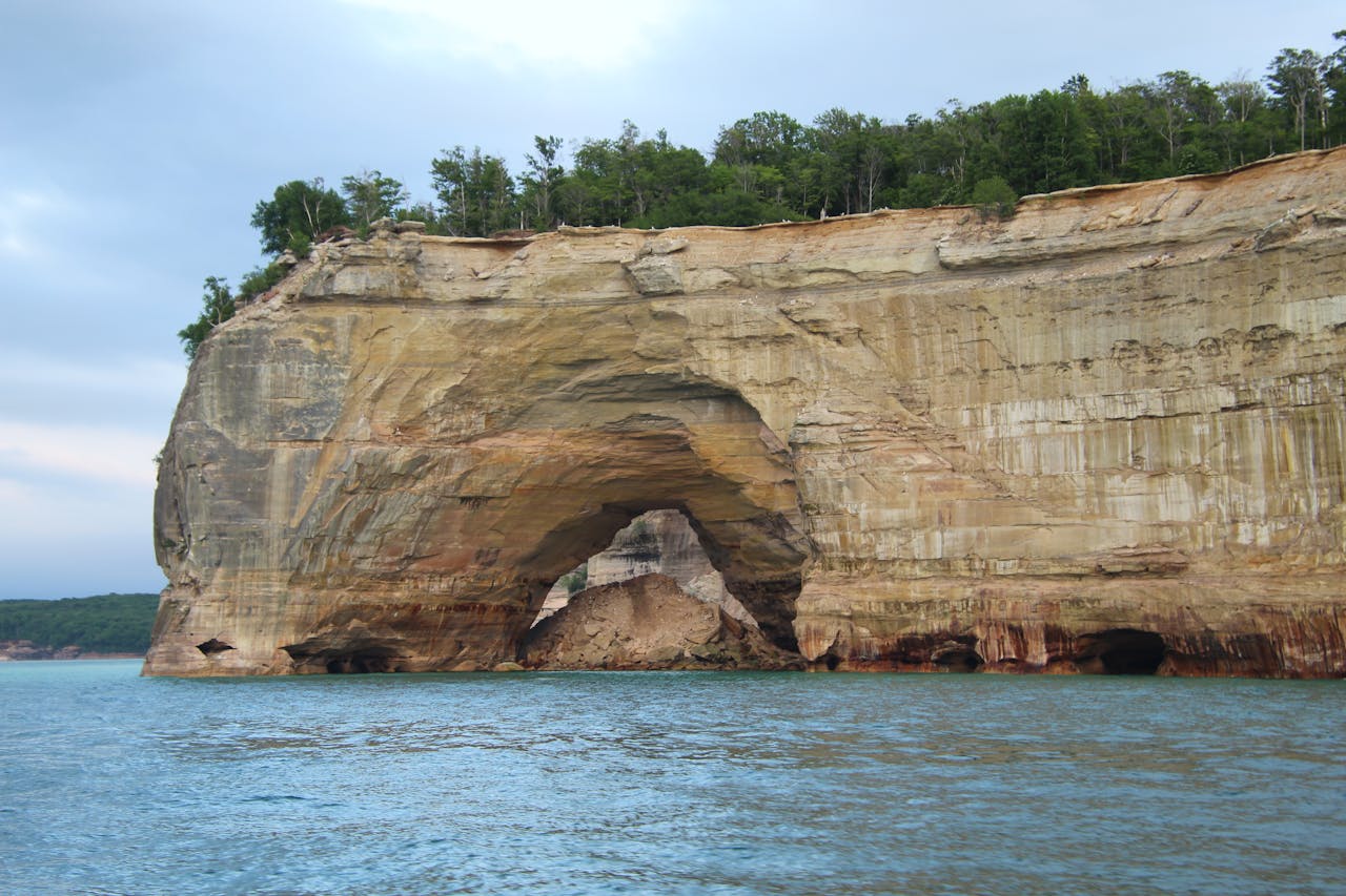
Stretching 42 miles along Lake Superior, this lakeshore features multicolored sandstone cliffs rising 200 feet above the water. Mineral stains create streaks of red, orange, and green across the rock faces.
Annual visitation averages about 900,000, modest for such dramatic scenery. Kayak tours typically cover 5 to 7 miles along sea caves and arches. Summer water temperatures hover near 60°F, while fall brings cooler 55°F days and quieter trails across 100 miles of hiking routes.
24. Shark Valley
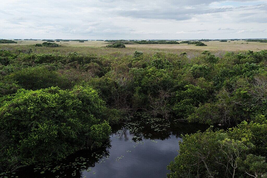
Located within Everglades National Park, this area features a 15-mile paved loop ideal for cycling or tram tours. Wildlife sightings are common, with dozens of alligators often visible along the canal banks.
An observation tower rises 65 feet, offering panoramic views across sawgrass marsh stretching for miles. Winter temperatures average 75°F, making it peak season for birdlife and comfortable exploration. Despite the Everglades spanning 1.5 million acres, this section remains surprisingly calm.